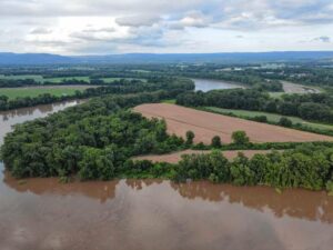
The Connecticut River in Sunderland a few days after peak flows in July. CONTRIBUTED/CHRISTINE HATCH
We’ve been hearing a lot about the “unprecedented” July rainstorms that have caused so much flooding and heartache for our farmers across the region. But were they really unprecedented?
I don’t mean to diminish the real impacts by asking, but I want to be clear-eyed about what we’re facing. What distinguishes the effects of the climate crisis from the weather of the moment is an examination of trends over long periods of time. In order to quantify changes in our long-term climate, we look at the historical record of weather data, calculate averages and standard deviations, and decide whether the event we saw falls far outside the historical record of events or not.
Surely this July, with a total rainfall that was triple “normal” rainfall for the month, would qualify as “unprecedented?” But what should we make of the fact that July 2021 also had triple normal rainfall over roughly the same region?
I’d like to unpack these phenomena in several ways: causes, historical context, the role of climate change; and what it all means for humans and the rivers we love.
First the cause: Everything else being equal, warm air carries more moisture. This means that for the exact same atmospheric physics, the air mass of the storm system will transport more water, and when the rain falls, more falls out all at once. Climate change yields a redistribution of water in time and space — an intensification of the hydrologic cycle.
Massachusetts has always had relatively uniform precipitation every month. We are also blessed on an average year with ample but not excessive rainfall (great for farming!), yet there has always been variation, even large floods and droughts.
In recent years, climate change has led to hydrologic intensification. This means increased and longer dry periods and more frequent droughts. It has also led to large amounts of precipitation coming all at once. This July’s rains were not exceptional in the hydrological record, but with climate change we can expect more frequent months with extreme weather. If weather patterns are changing over time, are we prepared?
Is our infrastructure ready for the new “normal?” The answer is no, partly because our estimates of what is normal have long been unreliable. This challenges our ability to build roads, drains, culverts and bridges that are appropriately sized for what’s to come. Following several very large regional floods in the 1920s and 1930s, the 1950s and 1960s saw construction of numerous flood control dams as well as a host of other flood control structures, which have been successful in preventing the large-scale flooding observed in those earlier storms.
The problem is, we grew to think floods were exceptional occurrences. So what’s different now, and what does it mean for our lives along the rivers we love?
What we’ve done across the landscape has created another problem. The more we develop places to live where it’s nice and flat, like the land along rivers, the more impervious surfaces we build. Roads, rooftops and parking lots convey water off of them very, very quickly.
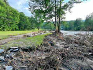
High stormflows eroded this streambank in Woodstock, Vermont, but damage was significantly mitigated by all of the living roots on the streambank and the available floodplain where the river could spread out. CONTRIBUTED/JOHN GARTNER
On July 16, I happened to be driving into Fitchburg when several inches of rain fell all at once. The roads were rushing rivers carrying orange-sized cobbles down them. Water pooled in low areas too deep to drive through; cutting off the downtown from two sides. I fled to high ground, past gullies being carved along the sides of the pavement, past a house that had put huge stone barricades up in front to block the torrent from going through their living room, and on the top of the hill was shocked to see a sanitary sewer acting like a fountain, water pouring out of it!
Where was it all coming from? The combination of a hot summer day carrying excess water in an already intense storm added to very little unpaved area to soak up the rain resulted in significant urban flooding.
With climate change and more impervious surfaces, there’s a lot more of this to come. A graph of the water height in the river is called a “hydrograph,” and impervious surfaces make “flashy” hydrographs that rise very quickly to high flows that can cause a lot of damage. A slower-rising, gentler hydrograph is produced by watersheds with lots of trees and soil and wetlands and low areas that can absorb a lot of the storm water over time, before overflowing and draining gradually into the river.
July 2023, with triple and quadruple “normal” rain in Vermont and Massachusetts combining in the Connecticut River led floodwaters to pour out onto the floodplains and over the floodplain farms. A big river is meant to flood — after all, that’s how those fertile farmlands were made. And the waters that spread out over floodplain farmland and forestland helped reduce the damage to cities and towns across our region.
But how do we make the farmers who lost their crops this year whole again? What if the whole watershed were a community, and lands that increase flood risk and damage with impervious surfaces paid into a bank account from which lands with farms and forests and wetlands that decrease flood severity and catch floodwaters could make a withdrawal?
For many in western Massachusetts and Vermont, the July flooding felt like Tropical Storm Irene (2011) all over again: flooded crops, damaged roads, expected delay until financial relief. And yet, there is reason to hope we are starting to manage our lands better.
In the Deerfield watershed, which was devastated by Irene, multiple efforts were made to live more harmoniously with rivers: floodplains were reconnected to slow and spread floodwaters, green infrastructure (large logs) was used to direct high flows away from critical road abutments, too-small culverts were replaced with larger ones — and these efforts seem to have paid off.
RiverSmart collaborator Eve Vogel and I drove through many of the areas that had been damaged during Irene, and we were heartened to see how well many weathered the storm, giving me hope for our coexistence with rivers into the future.